Route:
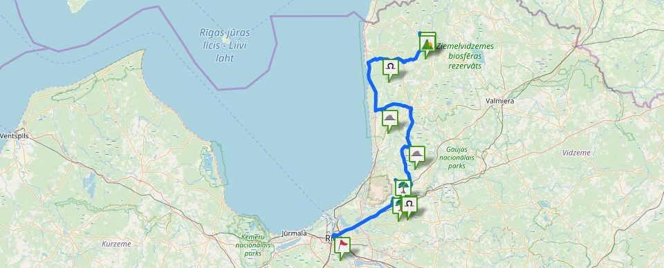
Rīga – Vangaži – Inčukalns – Sigulda – Krimulda – Sēja – Inčukalns – Rīga
Length of the route – km: 150 km
Suggested type of transport: car
Suggested time for visit: Spring, Summer, Autumn
Length of the route- hours: ~8h
The trip around the Riga Area Sacred Sites starts at the Dome Square, at the Dome Cathedral’s wall where a sacred site is located that is nowadays visually marked only with an informative tablet. Later on you leave Riga, taking the Vidzeme highway (A2) till Vangaži where you have to make a turn in the direction of Riga to drop in Vangaži, but before the turning, a dirt road begins that you have to follow till a church, on the left side of which, on the edge of the road, the Werewolf Pine-Tree is situated. Watch the trunk of the pine-tree carefully, behind it there are sometimes offerings laid!
Having returned to the Vidzeme highway (A2), proceed to Sēnīte, where you have to turn in the direction of Inčukalns (P10) and, avoiding the centre of Inčukalns, take a bypass till a railroad crossing. Right behind the railroad crossing, turn left at the crossing in the direction of Allaži and drive further till, on the right side of the road, there will be an indication sign and a path to the Černauski Stone.
Driving on further till the Allaži – Sigulda highway, at the crossing, turn left in the direction of Sigulda, where, in turn, turn in the direction of Riga at the crossing with the Vidzeme highway and proceed till the turning to the right to Kaķīškalns. Behind the Kaķīškalns Sculpture, turn left, taking the road leading down to the bank of the Gauja River and a pedestrian bridge. While driving, follow carefully the private property signs and other restricting signs, because it is impossible to drive very close to the pedestrian bridge and the Krimulda Devil’s Cave (Krimulda Velnala). On the river bank, opposite the Devil’s Cave, there is a facilitated recreation area.
To the next sightseeing place, walk through the centre of Sigulda, down the Gauja bridge and before Turaida, on the right side, there is a chargeable parking lot. At the parking lot, there is a WC, cafe, souvenirs. Having reached the Gūtmanis’ Cave (Gūtmaņala) by taking a path, climb up the stairs starting at the cave. Having climbed up, turn left, and a path across the Rats Hill (Rata kalns) will take you to the Trumpeters’ Hill (Taurētāju kalns), from which you can get back to the valley down the stairs, and turning left, you will come back to the Gūtmanis’ Cave, visiting on your way also the Maza Cave (Mazā ala) and Viktors’ Cave (Viktora ala).
From the parking lot, drive upwards to Turaida, and then at the crossing, turn left in the direction of Ragana (P7) and drive till the Krimulda Lutheran Church on the left side of the road. There you have two options – the first one is to leave your car in the parking lot at the church and, sightseeing on the way also the Kubesele Cave and following indication signs, walk along a forest path (3 km in one direction) till the bank of the Gauja River where the Big (Devil’s) Stone (Lielais (Velna) akmens) is situated. The second option is to turn left at the next road behind the church and drive to the old cemetery, where, having left the car in the parking lot, you have to walk along a path to the river about 100 m.
Later on heading to the Sēja Oak (Sējas ozols), drive till Ragana, turn in the direction of Limbaži and behind the Ragana’s boundary-mark, turn left at the first crossing in the direction of Sēja (P10). When driving into the centre of Sēja, there is an indication sign to the oak on the left side, but, having driven into the park till the very end, turn right, where a path leading to the park begins.
Leaving Sēja and heading to the last sightseeing place, turn right to Murjāņi, where you have to turn again right in the direction of Riga (A3) and drive till the Gauja Bridge. If you want to visit Inčukalns Devil’s Cave (Inčukalna Velnalu), there are two options again – right behind the bridge a dirt road winds, following which you can drive almost as far as the cave; still take into account that there are large pits and puddles on the way, because occasionally there are bogged meadows. The second option is to drive up to Sēnīte and, having turned right, crossing private property, leave the car in the forest at the indication sign at the beginning of the path, continuing then on foot. At the cave, there is a facilitated recreation place.
Having returned to the Vidzeme highway (A2), drive in the direction of Riga.
Contains information from the project:

Added by
Founder and maintainer of www.latvijas-pilskalni.lv, www.senvietas.lv and hillforts.eu.


