Route:
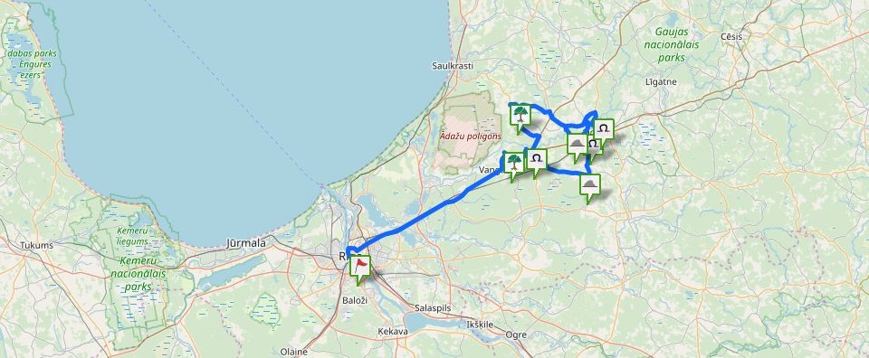
Rīga – Vangaži – Inčukalns – Sēja – Vidriži – Tūja – Salacgrīva – Staicele – Rīga
Length of the route – km: 150 km
Suggested type of transport: car
Suggested time for visit: Spring, Summer, Autumn
Length of the route- hours: ~8h
The trip around the Vidzeme Circle starts at the Dome Square, at the Dome Cathedral’s wall where a sacred site is located that is nowadays visually marked only with an informative tablet. Later on you leave Riga by taking the Vidzeme highway (A2) till Vangaži, where you turn in the direction of Riga in order to drop in Vangaži, but before the turning, a dirt road starts that has to be followed up to the church, on the left side of which, right on the edge of the road, the Werewolf Pine (Vilkaču priede) is located. Watch the trunk of the pine carefully, behind the bark there are sometimes offerings left!
From the Werewolf Pine, you come back to the Vidzeme highway and continue your way till Sēnīte, where you have to turn in the direction of Valmiera and at the rotation circle drive till you see a brown indication sign to the Inčukalns Devil’s Cave (Inčukalns Velnala) on the right side. The next indication sign in about half a kilometre will point at a forest path, following which you can reach the Cave. At the Devil’s Cave, there is a facilitated recreation place.
Having visited the Devil’s Cave, proceed in the direction of Valmiera till Murjāņi where at the crossing turn left to Sēja. In the Sēja centre, there is a brown indication sign to the Sēja Oak and, when driving into the park, you can see a peculiar construction – water tower, but, in order to get to the Oak, drive as far as the end of the park and turn right at the place where a path starts leading to the oak.
Later on from the Sēja park, go back in the direction of Murjāņi, but at the crossing right behind the inhabited place, turn left in the direction of Ragana (P6) and drive as far as Ragana, then turn in the direction of Limbaži (P9) and drive till Vidriži. On the way, you can drop in the BīriņiCastle. In Vidriži, turn right in the direction of Lēdurga and, crossing the inhabited place, look for a dirt road that turns left down to the AģeRiver. Having driven over the bridge, you can leave your car on the road side and climb up a hillock alongside the river bank, from which you can already see the Kaķi Cup-Marked Stone (Kaķu bedrīšakmens) located in a meadow, surrounded by bush.
Come back to Vidriži by taking the same road and drive on further to Limbaži. On the way, you can visit IgateCastle and have delicious meal in the Castle’s Mill. In Limbaži, you can walk a path winding along the Lielezers bank, watch birds from a watchtower, wander along the old town’s streets and visit the castle ruins.
Later on proceed in the direction of Tūja (P11) till Tūjasmuiža. You can reach the Tūja Hollow Stone in two ways. Having passed by Tūjasmuiža, on the left side of the road, you can see a field, in the middle of which there are two birch groves. The Tūja Hollow Stone is situated in the farthest grove if looking from the side of the inhabited place. The other option is to drive through Tūjasmuiža, on your right along a farm, in the direction of the groves, but you have to take into account that this road is used by agricultural vehicles and it can be hard to drive it, but it can take you closer to the object. Do not be surprised that you are followed by cows, they are very curious there!
Going further until the crossing with A1, turn right in the direction of Ainaži and in Svētciems look for the brown indication sign to the Liv Sacrificial Caves (Lībiešu upuralas) on the right side. At the next T-intersection, turn right and already after a few kilometres, crossing the SvētupeRiver, on the left side of the road, there is a parking lot, but the path to the caves starts on the opposite side of the road, alongside the private houses.
After the caves, it is recommended to take the road that leads straight ahead to Salacgrīva (go straight at the T-intersection) and continue the road till Ainaži where you have to turn right to Staicele (P15). Short before Staicele, look for the old road that winds along the bank of the Salaca. You can drive further along this small road as far as 150 m, then you have to walk and look for a forest path on the left side down to the river; following this path you can reach Vīksnas Devil’s Cave.
To reach the complex of the KarogupīteRiver, drive through Staicele and just in a few kilometres, there will be an inhabited place Karogi where on the left side of the road you have to look for an indication sign to the KarogiCaves. Taking this road to the facilitated water body with recreation and picnic places, you have to drive around to its opposite side, where on the forest edge there will be an indication sign to Dzelzsāmurs Great Stone (Dzelzsāmura Dižakmens), to which you have to walk along a forest path for about 200 meters.
Before coming back to the highway, you can visit also the caves (a small indication sign on the roadside), to which you have to walk, passing by abandoned buildings, down the stairs to the river, across the river and then along a forest path to the caves.
When driving towards the highway, look for a path on the opposite side of the highway at the river culvert that leads to Karogkalniņš Hill along a spring. Short before the bridge across the river, climb up the hillock on the left side, on top of the hillock, there will be the sacrificial stone.
You can come back to Riga in two ways – drive back through Ainaži or continue your way through Aloja and Limbaži.
Contains information from the project:

Added by
Founder and maintainer of www.latvijas-pilskalni.lv, www.senvietas.lv and hillforts.eu.


